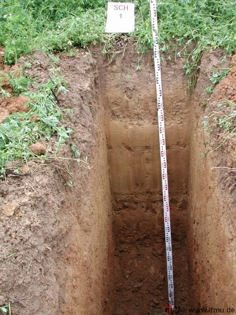
Hawke's Bay sits on a complex alluvial puzzle—layers of gravel, silt, and sand deposited by the Tutaekuri River over centuries, with groundwater often just 2 to 3 meters below ground level across much of Napier's flatlands. A desk study alone won't reveal the lenses of liquefiable material or the buried organic silts that plague the area. We open exploratory test pits to expose the stratigraphy directly, letting the soil tell its own story. When combined with spt-drilling results, the visual profile from a test pit clarifies the transition zones between competent gravels and compressible layers. On Napier Hill sites, where stability concerns shift to cut-and-fill behavior, this direct observation becomes even more critical—the slope-stability analysis depends entirely on knowing what the slope is actually made of.
A single well-logged exploratory test pit in Napier's alluvial soils can prevent a NZ$50,000 foundation redesign during construction.
Process overview
Napier's coastal humidity and seasonal rainfall patterns accelerate the weathering of exposed pit walls, so our field protocol moves fast: log, photograph, sample, and backfill—often within the same day. The procedure follows NZGS guidelines for engineering geological logging, capturing soil type, consistency, color mottling that indicates drainage issues, and any shear surfaces invisible to borehole sampling. Where groundwater is encountered, we document the inflow rate and stabilize the pit with sump pumping if needed, turning a simple observation into a
grain-size sampling opportunity. The key metric for most clients is bearing capacity confirmation at footing depth; seeing a clean gravel with no fines at 1.8 meters gives the structural engineer numbers they can trust, while a mottled silt at the same depth changes the entire foundation design approach.
Questions and answers
How much does an exploratory test pit program cost for a residential section in Napier?
For a typical residential lot requiring 3 to 4 pits to 3-meter depth, the cost ranges from NZ$720 to NZ$1,590 including machine time, operator, engineering logging, and a summary report. Sites with very dense gravels, restricted access, or requiring traffic management may fall at the higher end.
What's the difference between a test pit and a borehole for foundation investigation?
A test pit exposes a continuous vertical face, letting the engineer see layer transitions, lenses, and structural features directly. A borehole provides a discontinuous sample with depth. In Napier's variable alluvial soils, we often use test pits for shallow foundation confirmation and boreholes for deeper liquefaction assessment—they complement rather than replace each other.
Do you need council consent to excavate a test pit in Napier?
Generally no resource consent is required for temporary investigative excavations that are backfilled within 48 hours, but you must check service plans (beforeUdig) and avoid protected trees or archaeological zones. We handle the service location and traffic management if the pit is in the road reserve.
What safety measures apply to test pits deeper than 1.5 meters?
Under the Health and Safety at Work Act 2015 and our internal SWMS, any pit exceeding 1.5 meters requires either battering back the sides to a safe angle or installing hydraulic shoring before personnel entry. Gas monitoring is also implemented for pits in areas of known fill or organic material, as methane and carbon dioxide accumulation can occur in Napier's old landfill zones and peat deposits.