← Home · Investigation

SPT Testing in Napier: Accurate Soil Data for Hawke's Bay Projects

Together, we solve the challenges of tomorrow.

LEARN MORE →

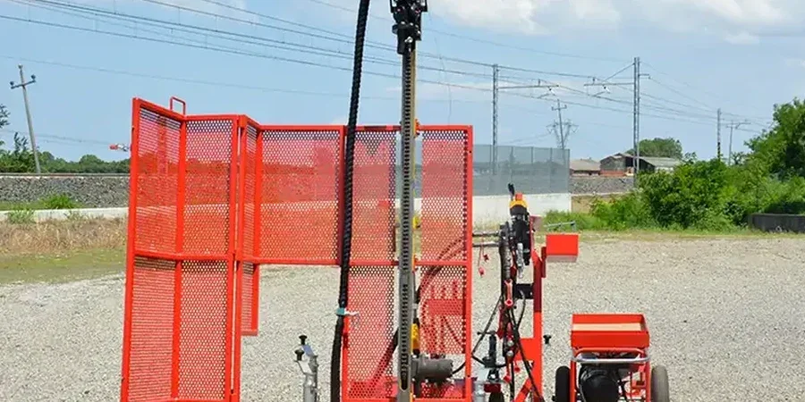
Overlooking penetration resistance in Napier's coastal sediments is a mistake we see too often. A bore log that stops at refusal without proper SPT values leaves structural engineers guessing about bearing capacity. The issue compounds in areas built on the 1931 earthquake uplift, where fill and marine deposits interleave unpredictably. For a city with Napier's seismic history, standard penetration testing isn't just a box to tick. Our laboratory team runs the split-spoon sampler to refusal, logging every 1.5 metres as NZGS guidelines specify. When site conditions demand continuous profiling, we pair the SPT data with a CPT test to capture thin liquefiable layers that hammer blow counts alone can miss. Getting N-values right from the start saves redesign costs later.

In Napier's post-1931 uplift zone, an SPT N-value of 4 at 8 metres depth signals a liquefaction risk that no desktop study can replace.

Methodology and scope

A site near Marine Parade behaves nothing like one up in Hospital Hill. On the former lagoon floor, we often record N-values below 5 down to 12 metres, reflecting the soft Ahuriri silts. Up on the limestone ridge, refusal can hit at 3 metres with N-values over 50. That contrast demands careful interpretation. Our rig operators follow the NZS 4402 split-spoon procedure: 300 mm seating drive, then two 150 mm penetration increments recorded separately. We report N as the sum of the second and third increments, unless refusal is met first. In gravelly lenses common around Taradale, the grain size analysis from our lab helps distinguish whether high blow counts mean a dense layer or just a cobble. Every SPT log we issue includes depth to groundwater, sampler type, and hammer energy calibration notes.
SPT Testing in Napier: Accurate Soil Data for Hawke's Bay Projects
Technical reference image — Napier

Local considerations

The Heretaunga Plains aquifer sits shallow across much of Napier, with static water levels often between 1.5 and 4 metres below ground. That means SPT work here frequently encounters saturated fine sands and silts susceptible to cyclic mobility during a large earthquake. The 1931 M7.8 event didn't just lift the coast; it rearranged the subsurface drainage. Today, any foundation design relying solely on presumed bearing values without site-specific N-values risks differential settlement the insurance assessor will notice first. Liquefaction assessment under NZGS Module 4 uses SPT blow counts directly: N1(60) values below 15 in clean sands trigger further analysis. In layered profiles, missing a thin loose sand between two stiff clay bands because the sampler wasn't driven deep enough can invalidate a seismic hazard evaluation. We've seen it happen.

Need a geotechnical assessment?

Reply within 24h.

Email: [email protected]

Technical parameters

ParameterTypical value
StandardNZS 4402 Test 6.5.1
Sampler typeSplit spoon, ID 35 mm, OD 51 mm
Hammer typeAutomatic trip hammer, energy-calibrated
Drive depth per increment150 mm (3 increments of 150 mm)
Reporting metricN-value (blows/300 mm) after seating drive
Typical borehole depth range6 to 30 metres depending on refusal
Groundwater monitoringLogged during drilling; stabilised level recorded

Associated technical services

01

SPT Borehole Drilling

Truck-mounted and track-mounted rigs for access across Napier's residential and commercial sites. We drill through fill, alluvium, and soft rock, performing SPT at 1.5 m intervals or at stratum changes as NZGS guidelines recommend.

02

Liquefaction Screening with SPT Data

Direct application of NZGS Module 4 using corrected N1(60) values. We calculate cyclic resistance ratios for each test depth and flag layers requiring further CPT or shear wave velocity investigation.

03

Combined SPT and Laboratory Testing

Split-spoon samples retrieved during SPT work are logged, bagged, and transferred to our lab. Partnering the penetration record with Atterberg limits and particle size distribution gives a complete soil classification for foundation design.

Applicable standards

NZS 4402:1988 Test 6.5.1 – Standard penetration test (SPT), NZS 3404 – Steel structures (referenced for seismic design parameters), NZGS Geotechnical Module 4 – Earthquake geotechnical engineering and liquefaction assessment, NZS 4203 – General structural design and design loadings (superseded by AS/NZS 1170 series but still referenced locally), MBIE Canterbury Technical Guidance – Liquefaction assessment using SPT data

Questions and answers

What does an SPT test in Napier typically cost?

For a standard SPT borehole program in Napier, plan on a range of NZ$1000 to NZ$1,370 per borehole, depending on depth, access conditions, and number of tests. Deeper holes in hill country with early refusal or tight access in the Ahuriri commercial area can push toward the upper end. Each quote is specific to the site and includes rig mobilisation, drilling, sampling, logging, and the field report.

How deep do you drill for SPT testing in Napier?

Depth varies with the project and ground conditions. For a typical residential foundation on the plains, 10 to 15 metres is common. On Hospital Hill or Bluff Hill where rock is shallow, refusal may stop the bore at 3 to 6 metres. For liquefaction assessments in the Ahuriri area, we often need 20 metres or more to penetrate the full Holocene sediment sequence.

Do you calibrate the SPT hammer energy?

Yes. Our automatic trip hammers undergo regular energy calibration to determine the actual energy ratio delivered to the rods. We record and report the energy ratio for each project, allowing engineers to correct raw N-values to N60 for liquefaction analysis and settlement calculations. Uncalibrated SPT data can overestimate penetration resistance by 30% or more, which is a risk we do not accept.

Location and service area

We serve projects in Napier and surrounding areas.

View larger map